|
|
|

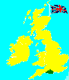
Verwood is a small village
situate in Dorset, England.
Aerial Photograph of Potterne Park
Directions to Verwood are as follows:
|
From the M4 west bound: M4 M25 Jct 15 (M4)
From M4 east bound: M4 Jct 17 (A350/A429/B4122)
|
From M5 west bound:
M3 Jct 14 (N) (M27)
From Dorcester: B3150 Jct A35/B3150
From Poole: A350 Jct A349/A350
|
The area has been inhabited for centuries, and earthworks at Stephen's Castle (in the form of a bowl barrow) and Pistle Down (long barrow) testify to the area's history.
The village itself is first recorded in 1329, when it was called Fairwood, and even today the area has much heathland and is in close proximity to the New Forest and the 600 acre Avon Forest Park. In the 18th and 19th centuries local clay led to a pottery industry, though little of this remains today.